ALOFT Image

Anticipatory Interdiction in Narco-Trafficking Networks

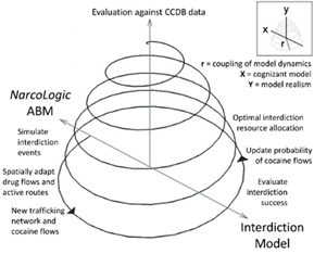
This research will investigate spatial adaptive behaviors of narco-trafficking networks in response to various interdiction strategies within the cocaine transit zone of Central America and associated maritime areas. This will be accomplished by developing integrated agent-based and interdiction optimization models to assess how the spatial and structural relationships of cocaine flows and prices along trafficking routes change in response to alternative interdiction strategies. Using a criminological lens, we will map the vulnerability of spaces in the so-called “transit zone” to enable a holistic analysis of the environmental and operational aspects of locations of new narco-trafficking activity.

Read More
ALOFT Image

Autonomous Logistics

The revolution in autonomous logistics is an anticipated transformation in high-efficiency, high-speed, and highly integrated transportation and supply-chain management systems that will rely on the deployment of unmanned and self-driving air, ground, and sea platforms. It will also rely on algorithms that enhance agent autonomy and on computational approaches to combinatorially complex location and allocation decisions. This project explores a series of interrelated logistical problems in the unmanned/autonomous context in order to anticipate and develop mitigation strategies for the challenges they represent.

Read More
Team Spatial Cognition Image

Collective Spatial Cognition

The goal of this research effort is to define and outline the field of collective spatial cognition as a foundation for further research. We approach this this research topic from multiple disciplinary perspectives in the spatial sciences, social and behavioral sciences, cognitive sciences, and information sciences. By collective spatial cognition, we refer to a wide range of phenomena in which people solve spatial problems in human collectives, from dyads to multi-team systems to crowds. Spatial problems include a broad array of activities, including navigation and wayfinding, spatial knowledge acquisition, location allocation and planning, design, and spatial communication.

Read More
Police Patrol Image

Police Patrol Design

The Laboratory has developed a new method for determining efficient spatial distributions of police patrol areas. This method employs a traditional maximal covering formulation and an innovative backup covering formulation to provide alternative optimal solutions to police decision makers, and to address the lack of objective quantitative methods for police area design in the literature or in practice. This research demonstrates that operations research methods can be used in police decision making, presents a new backup coverage model that is appropriate for patrol area design, and encourages the integration of geographic information systems and optimal solution procedures.

Read More